


Garmin Explore™
Beschreibung von Garmin Explore™
KOPPELN, SYNCHRONISIEREN UND TEILEN
Mit Garmin Explore können Sie Ihr Smartphone oder Tablet
1
mit Ihrem kompatiblen Garmin-Gerät
2
koppeln, um Daten für netzunabhängige Abenteuer zu synchronisieren und zu teilen. Nutzen Sie herunterladbare Karten für die Navigation überall.
• Garmin Explore benötigt eine SMS-Berechtigung, damit Sie SMS-Textnachrichten von Ihren Garmin-Geräten empfangen und senden können. Wir benötigen außerdem die Berechtigung zum Anrufprotokoll, um eingehende Anrufe auf Ihren Geräten anzuzeigen.
• Die fortgesetzte Nutzung von GPS im Hintergrund kann die Akkulaufzeit drastisch verkürzen.
OFFGRID-NAVIGATION
Bei Kopplung mit Ihrem kompatiblen Garmin-Gerät
2
können Sie mit der Garmin Explore-App Ihr Mobilgerät für Outdoor-Navigation, Reiseplanung, Kartierung und mehr verwenden – mit oder ohne Wi-Fi®-Konnektivität oder Mobilfunkdienst.
SUCHWERKZEUG
Finden Sie ganz einfach geografische Punkte – wie Ausgangspunkte oder Berggipfel –, die mit Ihrem Abenteuer in Zusammenhang stehen.
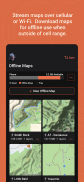
KARTEN STREAMEN
Für die Planung vor der Reise können Sie die Garmin Explore-App verwenden, um Karten zu streamen, wenn Sie sich in Mobilfunk- oder WLAN-Reichweite befinden – und so wertvolle Zeit und Speicherplatz auf Ihrem Mobilgerät sparen. Laden Sie Karten zur Offline-Nutzung herunter, wenn Sie sich außerhalb der Mobilfunkreichweite aufhalten.
EINFACHE REISEPLANUNG
Planen Sie Ihre nächste Reise, indem Sie Karten herunterladen und Kurse erstellen. Geben Sie Ihre Start- und Zielpunkte an und erstellen Sie automatisch einen Kurs, den Sie mit Ihrem kompatiblen Garmin-Gerät
2
synchronisieren können.
AKTIVITÄTSBIBLIOTHEK
Überprüfen und bearbeiten Sie auf der Registerkarte „Gespeichert“ Ihre organisierten Daten, einschließlich Ihrer gespeicherten Wegpunkte, Tracks, Kurse und Aktivitäten. Sehen Sie sich die Miniaturansichten der Karte an, damit Sie Ihre Fahrten leicht erkennen können.
GESPEICHERTE SAMMLUNGEN
Mit der Sammlungsliste können Sie schnell alle Daten zu jeder Reise finden – so können Sie den gesuchten Kurs oder Ort ganz einfach sortieren und finden.
CLOUD-SPEICHER
Die von Ihnen erstellten Wegpunkte, Kurse und Aktivitäten werden automatisch mit Ihrem Garmin Explore-Webkonto synchronisiert, wenn Sie sich in Mobilfunk- oder WLAN-Reichweite befinden, sodass Ihre Aktivitätsdaten im Cloud-Speicher erhalten bleiben. Für die Speicherung Ihrer Daten in der Cloud ist ein Garmin-Konto erforderlich.
LIVETRACK™
Mit der LiveTrack™-Funktion können Ihre Lieben Ihren Standort in Echtzeit verfolgen
3
und Daten wie Entfernung, Zeit und Höhe sehen.
Was Sie mit Garmin Explore erhalten
• Unbegrenzte Karten-Downloads; Zugriff auf topografische Karten, USGS-Quadsheets und mehr
• Luftbilder
• Wegpunkte, Tracking und Routennavigation
• Hochdetaillierte GPS-Reiseaufzeichnung und Standortfreigabe
• Unbegrenzter Cloud-Speicher von Routen, Wegpunkten, Tracks und Aktivitäten
• Online-Reiseplanung
1
Kompatible Geräte finden Sie unter Garmin.com/BLE
2
Eine vollständige Liste kompatibler Geräte finden Sie unter explore.garmin.com/appcompatibility
3
Bei Verwendung mit Ihrem kompatiblen Smartphone, der Garmin Explore®-App und bei Verwendung mit Ihrem kompatiblen inReach-fähigen Garmin-Gerät.
Die Bluetooth-Wortmarke und -Logos sind eingetragene Marken von Bluetooth SIG, Inc. und jegliche Nutzung dieser Marken durch Garmin erfolgt unter Lizenz.
Garmin Explore™ – Version 4.5
(22-05-2025)Garmin Explore™ – APK Informationen
APK Version: 4.5Paket: com.garmin.android.apps.exploreNeueste Version von Garmin Explore™
Weitere Versionen


Apps in derselben Kategorie

Das könnte dir auch gefallen...


